Posts

Monsoon 2022 arrives in Kerala on May 31st, 2022 signalling monsoon onset

Image
The 4-month long monsoon season signalled its arrival over mainland India, as the monsoon currents reached Kerala on May 31st, 2022. This signals an early arrival by 1-day.  According to the analysis by team WeatherCast, all the dynamical factors that are required for monsoon onset over mainland India has been satisfied. Very briefly, we summarise them below: 1. The westerly wind depth persists from surface to ~3.5 km that is commonly observed during monsoon season. This condition has been observed at many places over Kerala. 2. Under the influence of a gradually strengthening Somali jet, the low level wind speed over Kerala has increased to an average value of 12-15 knots. In the adjoining parts of Arabian Sea, the wind speed is much higher, showing values as large as 30 knots. Therefore, the wind speed is also quite sufficient for declaration of monsoon onset. 3. Light to moderate rainfall persistent activity has been seen over many parts of Kerala, and Karnataka. 4. The cloudiness q

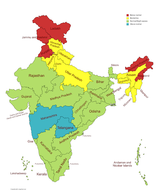
June 2022 subdivision wise monsoon forecast

Image
  June as a whole for India likely to perform BELOW NORMAL. As per our estimates, the countrywide rainfall for June would be 90% to 95% of total.            This forecast has been prepared after extensive analysis of the prevailing dynamics, such as equatorial waves (Rossby, Kelvin), La Nina and IOD conditions, MJO movement, Arctic Oscillation index, differential heating index, ITCZ movement, and MISO movement.   Disclaimer: Weather and climate predictions carry some amount of uncertainty and are subject to sudden changes. We won’t be liable for any decisions made on the basis of our data and analysis.   For more  detailed/refined information, connect with us on  www.weathercast.in  or write to us at  info@weathercast.in . We offer customized solutions as per your needs.     Subdivision Name Rainfall LAKSHADWEEP Normal A & N ISLAND Normal COASTAL ANDHRA PRADESH Above Normal ARUNACHAL PRADESH Normal ASSAM & MEGHALAYA Normal BIHAR Below Normal KONKAN & GOA Normal SAURASHTRA &

Monsoon 2022 revisions

  Monsoon 2022 prediction (Minor revisions)                                                   Prepared and copyrighted by WeatherCast   If your business needs division-wise or district-wise predictions, then please contact us and avail our services. We also provide regional, local, and hyper-local weather and climate services for businesses and organizations to be prepared for any unseasonal or extreme event and bring sustainability and resilience. You can reach us at  info@weathercast.in  or  weathercastindia@gmail.com . Visit us at  www.weathercast.in     Monsoon Onset:   Inter Tropical Convergence Zone (ITCZ) is well above the EQ now, indicating a strong cross equatorial flow. The strength of westerlies is also increasing. Furthermore, the Somali jet is getting activated near the coast of Somalia, resulting in strong moisture convergence in the Arabian Sea. Lastly, the Rossby wave action is also strong and MJO will be moving into the Indian Ocean temporarily and then would be moving

Cyclone ASANI

Image
Our team has been on the fence with regards to the SEVERE CYCLONIC STORM (SCS) ' ASANI' , since the ridge dynamics were highly tricky. The cone of uncertainty surrounding this cyclone is quite huge, with still some divergence in the weather models as to its exact track, landfall location, as well as intensity. This uncertainty is very uncommon given that the cyclone is just 48 hours within possible landfall. However, as an upcoming (read startup) private player in the field of weather and climate services, it is important to spell out what we feel is likely to happen based on the dynamics that we interpret. The Cyclone has enough fuel to maintain Cyclonic Storm status. The vertical wind shear is the only unfavourable factor, but it is not too high. The ridge action has been the main X-factor. The Indo-Pacific ridge movement has been very unstable for past few days and hence the models were divergent on the track. But now, it looks like the Indo-Pacific ridge has moved closer to

Normal monsoon expected in 2022

Image
Monsoon 2022 prediction        (Posted on: April 14, 2022)                                                                Prepared and copyrighted by WeatherCast Pvt Ltd   If your business needs division-wise or district-wise predictions, then please contact us and avail our services. We also provide regional, local, and hyper-local weather and climate services for businesses and organizations to be prepared for any unseasonal or extreme event and bring sustainability and resilience. You can reach us at  info@weathercast.in  or  weathercastindia@gmail.com . Visit us at  www.weathercast.in     The monsoon 2022 season is less than 60 days away and we at WeatherCast LLP analyzed all available data and maps and have come up with our version of the forecast. The forecasts presented in this document are a combination of statistical modeling, physical interpretation from long-range models on evolution of major drivers such as ElNino Southern Oscillation (ENSO), Indian Ocean Dipole (IOD), Indi

LOW PRESSURE IN EQUATORIAL EAST INDIAN OCEAN TO MOVE INTO SOUTH-WEST BAY BY MARCH 3, 2022

Image
  The low pressure system intensified into a depression on March 3, 2022 in the early morning hours. At WeatherCast, outlook remains the same wherein as of today the impact would be felt over SriLanka and TamilNadu coasts in the coming days. The rains are imminent for SriLanka and TamilNadu coasts, the precise timing is hard to pin point. But the likely window of heavy rains looks to be from evening of March 4 to morning of March 6.  Considering the prevailing dynamics, we at WeatherCast feel that the system doesn't have enough fuel to transform into a Cyclonic Storm. That said, if the system spends more time over ocean (due to ridge action), then it could become a borderline cyclone (primary due to the fact that the system gets more time to get  organised with a well-formed outer structure). Outlook for March 3 to 6, 2022   Red box  near SriLanka and adjoining south peninsular India indicate possibility of very heavy rains with total average fall 150-250 mm spread over 2 to 3 days

Impact of remnants of cyclone Gulab on Maharashtra

Image
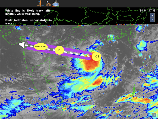
  HOW CYCLONE GULAB C OULD IMPACT MAHARASHTRA? Cyclone Gulab would make landfall near South Odisha and North Andhra Pradesh, possibly very close to Sompeta in Srikakulam district on September 26 late evening. Once the cyclone makes landfall, the dissipation process would begin due to land friction. However, it is likely that the dissipation mechanism may not be rapid and would be gradual. Therefore, the storm is likely to maintain some strength as it moves inland. The westerlies moisture drag from Arabian Sea would also help system maintain its intensity as a DD (Deep Depression) up until Chattisgarh/Telangana. As the system enters Maharashtra, it may weaken to a Depression (D) and would likely maintain that status as it traverses through the state. This post is about the likely impact of GULAB on Maharashtra. Even though no direct impact is expected, the remnants of Gulab or so called weakened Gulab would very likely impact the state. Briefly, I summarise the possible impact below: (F