LOW PRESSURE IN EQUATORIAL EAST INDIAN OCEAN TO MOVE INTO SOUTH-WEST BAY BY MARCH 3, 2022

The low pressure system intensified into a depression on March 3, 2022 in the early morning hours. At WeatherCast, outlook remains the same wherein as of today the impact would be felt over SriLanka and TamilNadu coasts in the coming days.
The rains are imminent for SriLanka and TamilNadu coasts, the precise timing is hard to pin point. But the likely window of heavy rains looks to be from evening of March 4 to morning of March 6.
Considering the prevailing dynamics, we at WeatherCast feel that the system doesn't have enough fuel to transform into a Cyclonic Storm. That said, if the system spends more time over ocean (due to ridge action), then it could become a borderline cyclone (primary due to the fact that the system gets more time to get organised with a well-formed outer structure).
Outlook for March 3 to 6, 2022
Red box near SriLanka and adjoining south peninsular India indicate possibility of very heavy rains with total average fall 150-250 mm spread over 2 to 3 days.
Green box over TamilNadu and Ghat sections indicate possibility of moderate to heavy to rains with total average fall of 60-120 mm spread over 2-3 days.
Rest of TamilNadu likely to witness intermittent moderate spell.
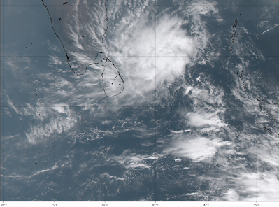 |
| Himawari satellite showing intense convective clouds bands with a disorganised |
Disclaimer: The views provided here are based on the prevailing weather patterns and available data. Weather and climate predictions carry some amount of uncertainty and are subject to sudden changes. We won’t be liable for any damages due to decisions made on the basis of our analysis. The details provided in this document are copyrighted by WeatherCast LLP.
Comments
Post a Comment