MONSOON 2020: CAN IT WASH OUT THE NEGATIVE IMPACTS OF COVID19?
As I write this blog, India is battling a deadly outbreak, COVID-19, that has caused a lot of distress to many echelons of our society. As we approach closer to the end of the "National Lockdown", one could only hope and pray that we have caught the beginning of a plateauing curve for this life-threatening virus.
For an agrarian country like India, usually at this time of the year the performance of the "Indian summer monsoon" attracts all the curiosity, owing to its notorious nature. But this year, we already have started with so much negative impact that the pressure on "Monsoon 2020 performance" is more than ever. Among all this, we could only hope that a good monsoon washes down all the negativity and brings our economy on track. With this preface, let us move on the (unofficial) Monsoon 2020 forecast.
Monsoon 2020 has a lot of hope riding on it. It is following a bumper bumper (yes I am indeed it twice) Monsoon 2019, which was 110% of LPA (thanks to the strongest +IOD event), and its performance is key to offset some of the lethal effects of COVID-19.
Without further delay, let me present my version of #Monsoon 2020 forecast in form
of an image, which has all the details in it.
of an image, which has all the details in it.
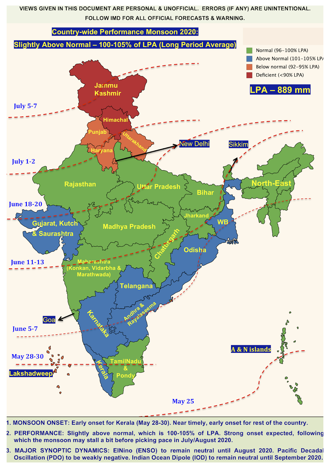
MONSOON 2020 KEY FEATURES:
1. Early onset in Kerala (~May 28-30). Near normal or early onset in rest of the country. For e.g. it is likely to reach Mumbai on its normal date ~ June 10 (+/- 1 day).
2. Slightly above normal countrywide performance (100-105% of LPA. LPA is 889 mm).
3. South India to get slightly excess rainfall.
4. North India likely to end in a deficit.
5. July & August will score well in terms of rains. These months will be above normal.

There are the five factors that I looked into while giving this forecast.
I have looked at all these factors in great detail including the spatial plots, the present vertical ocean structure from models, and many other graphical features. Despite this, there could be some inconsistencies, since weather has its own mind (that too in long-range).
Here, I am just giving the gist of the status of these synoptic scale weather patterns.
1. ElNino - This is in neutral phase now, with a Nino index of ~ 0.5. It is likely to remain neutral until August 2020, owing to a weak action of equatorial Kelvin wave.
2. Indian Ocean Dipole - The IOD is neutral and will continue to be in neutral zone until September. This is again owing to the fact that there is not much cooling activity near the Sumatra coast owing to the weak action of Equatorial Rossby and Kelvin waves.
3. Pacific Decadal Oscillation - The PDO is in a weakly negative state, which is good for Asian continent, since it is associated with normal rainfall activity.
4. Madden Julian Oscillation or Monsoon Intra-seasonal Oscillation (MISO) - During monsoon season the MJO becomes MISO. It is expected that the MISO will be strong owing to a normal Walker circulation cell. Moreover, at this time of the year, both the Bay of Bengal and Arabian Sea are showing optimal Sea surface temperature (SST) that are needed for triggering convection.
This is also clear from the abundant "Pre-monsoon showers" that we are seeing in South and Central India. This is generally a good sign for monsoon.
This is also clear from the abundant "Pre-monsoon showers" that we are seeing in South and Central India. This is generally a good sign for monsoon.
5. Southern Annular Mode (SAM) - SAM over the years has shown a tendency to remain positive or neutral during the Indian monsoon months.
A positive SAM is good since it will allow moisture incursion from the Eastern Pacific towards Australian and Asian subcontinents. If SAM is positive or neutral, then Indian monsoon is likely to be normal or slightly above normal.
All these five weather dynamical patterns indicate that the Monsoon 2020 is likely to perform well. If this outlook indeed holds true, then it would be a much needed positive change for India and its economy, which is currently under the grip of #COVID.
The X-factor is Local dynamics - None of the models can accurately capture the effect of local dynamics in the Indian Ocean.
Hence, the local and hyperlocal rainfall patterns, i.e. at district level or city level rainfall, is not mentioned in the forecast, since there will be huge variations. As always, there is going to be flooding in some districts and possibility of drought in others.
The only thing we could say now is the overall country-wide performance for Monsoon 2020 is going to be above normal (100-105% of LPA). This in itself is a good news, since it would mean good water supply for most parts of India.
Another X-factor, at least for Monsoon 2020, is the effect of global lockdown. Presently, it is unclear how the global lockdown and reduced CO2 emissions will affect the monsoon. We wait and watch!!
********************
MUMBAI MONSOON - I am expecting a normal rainfall over Mumbai & its suburbs.
Santacruz to get ~ 2500 mm, IIT Powai to get ~ 3500 mm.
1. June likely to start on a strong note and then get a little sluggish. Overall June will be normal in terms of rainfall.
2. July and August likely to perform slightly above normal in terms of total rainfall.
3. September rainfall may be slightly below normal.
-----------------------------
Signing off with a hope of an Above normal Monsoon 2020.
Good health to all of you!! Stay safe and healthy.
And see you soon with more updates on Monsoon 2020.
You can follow my twitter handle @WeathrCast (Twitter name: WeatherCast).
------------------------------
Disclaimer: The content given here are all personal views and the author will not be held responsible or held liable for any oversight or misinterpretation.

Comments
Post a Comment