Impact of remnants of cyclone Gulab on Maharashtra
HOW CYCLONE GULAB COULD IMPACT MAHARASHTRA?
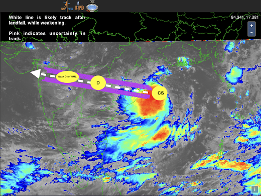
Cyclone Gulab would make landfall near South Odisha and North Andhra Pradesh, possibly very close to Sompeta in Srikakulam district on September 26 late evening.
Once the cyclone makes landfall, the dissipation process would begin due to land friction. However, it is likely that the dissipation mechanism may not be rapid and would be gradual. Therefore, the storm is likely to maintain some strength as it moves inland. The westerlies moisture drag from Arabian Sea would also help system maintain its intensity as a DD (Deep Depression) up until Chattisgarh/Telangana.
As the system enters Maharashtra, it may weaken to a Depression (D) and would likely maintain that status as it traverses through the state. This post is about the likely impact of GULAB on Maharashtra.
Even though no direct impact is expected, the remnants of Gulab or so called weakened Gulab would very likely impact the state. Briefly, I summarise the possible impact below:
(FOLLOW IMD FOR OFFICIAL UPDATES)
------
September 26:
Due to convergence of winds, scattered/isolated evening thunderstorms are very likely over Vidarbha and Marathwada. This could range from scattered moderate to isolated heavy, with more concentration towards Nanded, Chandrapur, Amravati and nearby areas.
------
September 27:
As the weakened system moves inland, there is going to be a strong moisture convergence zone created. This would give widespread moderate to heavy rains to Vidarbha and Marathwada, with scattered and isolated heavy to very heavy rains.
------
September 28:
Rainfall activity will shift further west as the system traverses west. Marathwada & Vidarbha would now only get scattered moderate to heavy rains with possibility of isolated heavy rains as the eastern bands of the system would be over these places (which are not too strong). From 28th late afternoon, rainfall activity would likely reduce significantly over Marathwada & Vidarbha.
The western/south western bands (which are usually quite strong) would now be over Northern Maharashtra and Ghat areas and also over North Konkan.
Pune district would like get moderate to heavy rains with heavy rains expected over Ghats.
Nashik district is likely to get heavy rains
Mumbai would get moderate to heavy rains, with chances of some continuous heavy rains for a few hours. Varied intensity rainfall expected over Mumbai, Thane, Raigad and Ratnagiri.
(More impact closer to Mumbai and above latitude due to preferential moisture drag. So Ratnagiri district would possibly not get impacted too much, so mostly moderate rains with intermittent heavy showers).
Palghar & Dahanu would likely get impacted with heavy to very heavy rains.
Satara & Kolhapur district would likely get only scattered moderate rains from the peripheral bands and due to moisture incursion. Moreover, these rains would be concentrated over Ghat sections.
-------
September 29:
As system moves further west, only North Konkan would get rains from the eastern bands of the system. Mumbai would get clear by Sep 29th morning with likelihood of some scattered moderate rains and Palghar and beyond would get clear by Sep 29th afternoon (mostly moderate scattered rains).
-------
Disclaimers:
The content given here are all personal views and the author will not be held responsible or held liable for any oversight or misinterpretation.


Comments
Post a Comment