Why monsoon is a hard nut to crack?
The infamous Indian monsoon is a bitter-sweet intra-seasonal system known to bring its share of joy and sorrow. Probably one of the very few weather systems world-wide that has such a characteristic. People eagerly look forward to the monsoon showers (that gives respite from the scorching heat) and at the same time dread the fury that it brings along.
Monsoon, in short, is an atmosphere-ocean (or air-sea) coupled system that brings widespread rains primarily to the tropical belt. From India's viewpoint, it is indispensable for agriculture and is dubbed as the real "finance minister" of the country. Well, from the basic definition of monsoon, it looks like if we capture the air-sea interactions, then one could have the monsoon dynamics fully figured out. Yes, true, but it comes with a caveat, and not just one...many!
Atmosphere and ocean are dynamically controlled by various parameters namely, wind (zonal, meridional, and vertical components), air temperature, pressure, & density, sea temperature, pressure, & density, moisture, salinity. Each of these variables is dynamically governed by a mathematical equation. So 14 variables in total, and there are 14 governing equations. Alright, so what's the problem? We should be able to solve each of these 14 variables.
CAVEAT #1:
Even though we have have 14 unknowns and 14 equations, the equations are highly non-linear, and hence are not straightforward to solve using pen & paper. Therefore, we resort to supercomputers, which unravel the intricate dynamics of global weather and climate using models, famously known as GCMs. These GCMs are nothing but a cluster of mathematical dynamical equations. Fine, let the computers solve these equations. What's the problem? Here is where we come across few other caveats (which I will list below).
Monsoon prediction is analogous to a funnel and could be divided into three sub-sections:
Monsoon prediction is analogous to a funnel and could be divided into three sub-sections:
1. Global ocean and atmosphere dynamics :
This represents the top of the funnel; which is analogous to large-scales in weather.
This represents the top of the funnel; which is analogous to large-scales in weather.
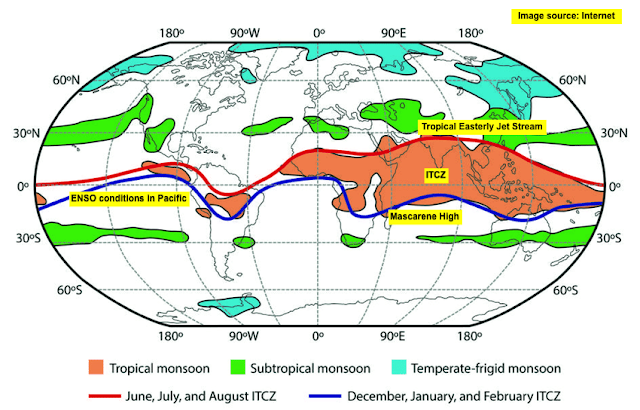
As the name suggests, these are features which have a well-established relation with the Indian monsoon. These include the Tropical easterly jet, ENSO, ITCZ, Madden-Julian Oscillation, and Mascarene high, (represented by black text in yellow box in the image below). These are known as synoptic scales (generally ranging around 500-1000 km in space and occur on the order of 30 - 90 days time-scale).
In general, the global features & dynamics are well-resolved by the GCMs. This basically means that the location, time-scale, and approximate intensity of these global dynamics is well represented in the models.
This is the reason why we are able to predict the onset and withdrawal of monsoon with a far greater accuracy, since the tele-connection between global features and monsoon is somewhat well-understood.
This is the reason why we are able to predict the onset and withdrawal of monsoon with a far greater accuracy, since the tele-connection between global features and monsoon is somewhat well-understood.
2. Regional ocean and atmosphere dynamics:
This represents the middle the funnel, which is narrow; the region analogous to meso-scale dynamics (generally ranging around 10-500 km in space and occur on the order of few days to few weeks in time-scale).
This represents the middle the funnel, which is narrow; the region analogous to meso-scale dynamics (generally ranging around 10-500 km in space and occur on the order of few days to few weeks in time-scale).
The GCMs are able to capture some of the features of the Indian ocean, namely the East Indian Coastal Current (EICC), meso-scale anticyclonic eddies (and similar miso-features).
The model breakdown starts to occur when it is trying to capture the submeso-scale features (like submeso-scale eddies, filaments, wind blockage effect due to Tibetan plateau, convection etc.). This brings us to the second caveat.
CAVEAT #2:
The reason GCMs break down is due to the fact that most of the global models have a limited spatial resolution of 10 km, and any feature below this length-scale is not captured. Some models have a resolution of 25 km.
In very simple terms, this is analogous to the fact that a human eye can clearly see objects that are closer to them. As the object moves far away, it becomes invisible to the eye. This is precisely the case with GCMs.
The immediate question would be why not run the GCMs at a high resolution say ~1 km. The simple answer is computing resource, which increases exponentially as resolution reduces. If one were to run GCMs at high resolution, then given the present computing resources, the models won't be able to complete the run and we would be unable to provide any kind of forecast.
This moots the whole idea of weather forecasting.
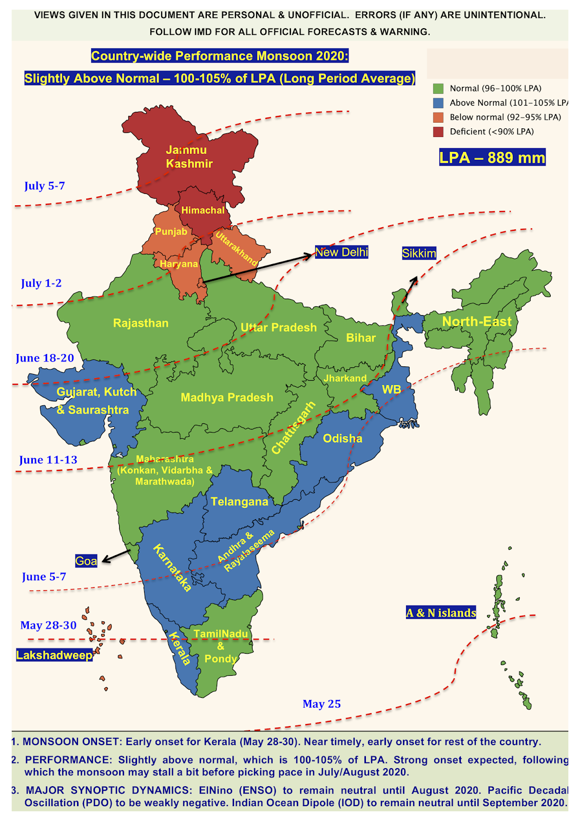
Due to the inability to resolve these regional features, the monsoon prediction starts to breakdown, wherein we are unable to accurately predict how much rainfall (countrywide) we will get, i.e., XX% of normal. Predictions of rainfall go awry, wherein we end up with either deficit or excess in any given season (which trumps the forecast of say a normal monsoon season predicted by the weather agencies).
3. Local terrain dynamics and associated turbulence:
This represents the bottom of the funnel, which is the narrowest; the region analogous to small-scale turbulence and associated dynamics (generally < 1 km, and typically ranging from 10 m -100 m in space and occur on the order of few hours in time).
This represents the bottom of the funnel, which is the narrowest; the region analogous to small-scale turbulence and associated dynamics (generally < 1 km, and typically ranging from 10 m -100 m in space and occur on the order of few hours in time).
These blobs of turbulence created due to topography or so called boundary layer processes (both in ocean and atmosphere) are the rouge elements in any GCM and are the detrimental to weather forecasting.
All these small-scale features that we see in the above images carry energy and determine the convective activity on a local scale, which in turn determines the propensity of rainfall. In all the global weather models, these features are "parameterized".
What do I mean by "parameterized"?
Take for instance an object which is circular in shape. You take snapshots of that object using camera and then write an image processing algorithm that would capture the shape of the object accurately.
Now you take the same algorithm and apply it to any random shape - sphere, cylinder, cube, curved object etc. You know that it is not going to work accurately, but you still go ahead and use the algorithm because you have no other choice. So you settle for whatever this "algorithm developed for circular shape" gives as output for other shapes.
CAVEAT #3:
Parameterization!! And this is one of the biggest caveats that lead to failure of models for Indian monsoon and weather dynamics in general
The monsoon is controlled by innumerable local factors, whose dynamics are parameterized. Unless we improve the parameterizations, we won't be able to master the art of prediction the exact spatial distribution of rainfall on an city-scale or even a district or state-wise scale.
Caveats #2 and # 3 are the areas where a lot of research is needed (and it is ongoing), which would possibly help us in improving the art of monsoon prediction.
I feel, we would never be able to master monsoon dynamics, since tackling Caveat #3 is a mammoth task. Nevertheless, if we are able to handle Caveat #2 and to some extent have a suite of parameterizations (rather than one size fits all), then we would be able to have a much better handle on monsoon dynamics (at least in the short range, say 7-10 days forecasting period).
I feel, we would never be able to master monsoon dynamics, since tackling Caveat #3 is a mammoth task. Nevertheless, if we are able to handle Caveat #2 and to some extent have a suite of parameterizations (rather than one size fits all), then we would be able to have a much better handle on monsoon dynamics (at least in the short range, say 7-10 days forecasting period).
This would go a long way in bringing smile and relief to the agrarian community, which is the most hit by the monsoon and its vagaries.
Disclaimer: The content given here are all personal views and the author will not be held responsible or held liable for any oversight or misinterpretation.


Comments
Post a Comment