Dynamics behind extreme rains in Ghat section between Aug 06-09, 2019
Very heavy rains are no stranger to Ghat sections of Maharastra, Karnataka, Kerala, and TamilNadu and the districts nestled within the Nilgiris and the Sahyadris.
However, extremely extremely heavy rains ( > 300 mm/day) that are continuous in nature require some local dynamics that help in continuous cloud burst like situation.
Here, I make an attempt to explain the dynamics behind these events.
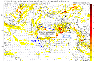
BAY OF BENGAL SYSTEMS + OFFSHORE TROUGH IN ARABIAN SEA:
 It all starts from the "Bay of Bengal", where a low pressure system forms. Under the influence of tropical easterlies, these systems move westward towards land, and dissipate due to frictional effects, land cooling effect, and moisture dissipation (i.e. the system runs out of moisture - the heat engine needed to run the system - and hence doesn't sustain).
If the system is strong (i.e. depression or deep depression, it will go all the way to the west coast and sustain for a longer time - e.g. the system that formed between Aug 06-Aug 10, 2019).
The basic mechanism is that the low pressure system activates a trough in the Arabian Sea, which allows warm air from the Arabian Sea to interact with the cold air from land. The cold air over land is due to an instability at higher level (500 mb) that is a result of dipping pattern of winds.
OROGRAPHICAL LIFTING NEAR GHATS:
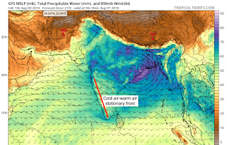
 The interaction between the warm and cold air is called a "FRONT", which aids in convection and formation of rain bearing Nimbus clouds. This happens due to the orographical lifting.
In the Ghats sections, due to the topography, the front becomes stationary - and is called a "Stationary Front". A stationary front allows convection in a small region and results in intense cloud formation for many days.
MOUNTAIN LEE WAVES (THE BOOSTER):
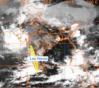
Exacerbating the situation is the formation of lee waves on the lee side of the mountain. These are special atmospheric waves that form as a results of stationary front.
These waves get trapped on the lee side of the mountain. [The lee waves pattern can be seen in atmosphere from satellite images.]
 Owing to the dynamics of the lee waves (refer to any meteorological book), these lee waves provide energy vertically upwards, adding additional mode of convection that form very intense clouds due to updraft of moisture.
Moreover, the vertical energy is such that is moves towards the windward side of the Ghats. This results in very intense formation of clouds in the windward side.
Due to the trapped lee waves, the leeward side of the mountain also see clouds bands and hence gets heavy rains. However, the Ghat section get extremely heavy rains, resulting in landslides. Moreover, this rain water moves downstream (due to higher elevation of Ghats) to districts which are on the slope of the Ghats, resulting in extensive damage.
Either these waves have to break down or loose energy for the intensification to die down. This happens when the atmospheric instability reduces, which in turn happens when the low pressure system dissipated.
The Lee wave phenomena was the reason behind 2018 Kerala floods, where a stationary front was formed. The strong upper level instability resulted in the formation of lee waves and result is clear from the above dynamics.
You can follow my twitter handle @SriGMFL
Disclaimer: The content given here are all personal views and the author will not be held responsible or held liable for any oversight or misinterpretation.


Comments
Post a Comment