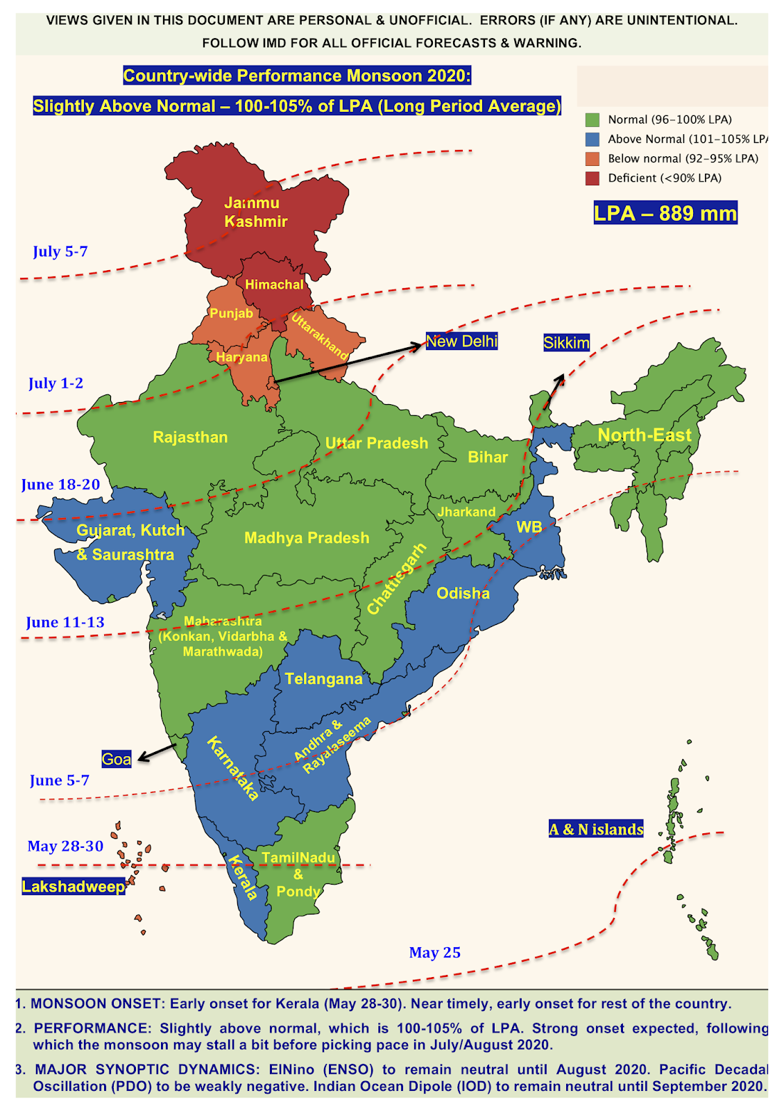
Onset of Indian summer monsoon
The onset of Indian summer monsoon (or southwest monsoon) is the most anticipated event for the Indian population. The first monsoon shower is the most awaited one as many seek respite from the scorching heat, little ones gleefully wanting to play in the cool showers, and the agricultural community get in full swing to prepare the land for farming. Over the past few years, owing to climate change, the onset has been delayed (https://www.firstpost.com/economy/imd-forecasts-delay-in-onset-of-monsoon-may-hit-kerala-coast-around-5-june-1971211.html) and the monsoon itself has been erratic, with brief periods of heavy rain (active phase) and periods of no rain (break phase). This is in contrast to a decade or two back, when the onset on monsoon would be well-timed and the nature of monsoon was also steady (with consistent rains through out the season). However, urbanisation, greenhouse pollution, deforestation, and many other anthropogenic activities have led to the late onset and inconsistent monsoon. Inspite of this whimsical nature, there are many factors which help in predicting the onset of summer monsoon. The onset of monsoon for India is based on the monsoon winds first hitting the Kerala coast, which is usually in the fourth week of May (May 28th-30th). In this blog, let's venture into the factors that help in predicting the onset of the monsoon for India subcontinent and the outlook for onset for 2018.
There are five important factors that help in predicting the onset of monsoon.
 1. Low lying monsoon jet (LLJ): The Somali Low Lying Jet (SLLJ) is shown in the top figure. It is a fast moving stream of westerly air, which comes in from east Africa bringing moist air to India. The jet is confined within top 100-500 m of the atmosphere. The genesis of this jet is due to a high pressure region created in the Somalian coast due to coastal ocean upwelling in the west Arabian Sea. The high pressure region pushes the moist wind towards the India sub-continent. The formation of this SLJJ is important factor for the onset of Indian monsoon as it brings constant supply of moist air along with powerful winds.
2. Wind reversal associated with LLJ: Normally, the winds near the equator are easterly trade winds. However, during the monsoon period, there is a wind reversal associated with the LLJ formation. Therefore, the reversal in the wind pattern is also important for predicting the onset.
 3. Location of the monsoon trough: The Inter Tropical Convergence Zone (ITCZ) is normally positioned about 5°N of the equator. It shifts over the Gangetic plains during the summer. The melting of ice during the summer causes a low pressure region to form near the Gangetic plains. The high pressure near Somalia coast coupled with the low pressure region in Gangetic region causes the moist winds (picking up moisture from the Arabian Sea) to blow across the Indian subcontinent. It is also known as the monsoon trough during the monsoon season. The shift in the ITCZ and hence the monsoon trough is shown in image (b) on the right. The trough is normally associated with a low pressure region and cyclonic winds (see my previous blog on wind patterns). Therefore, the trough is a strong zone of moisture convergence and hence updraft and precipitation. The shift in the ITCZ (and the location of monsoon trough) is also important for predicting the onset.
 3. Location of the monsoon trough: The Inter Tropical Convergence Zone (ITCZ) is normally positioned about 5°N of the equator. It shifts over the Gangetic plains during the summer. The melting of ice during the summer causes a low pressure region to form near the Gangetic plains. The high pressure near Somalia coast coupled with the low pressure region in Gangetic region causes the moist winds (picking up moisture from the Arabian Sea) to blow across the Indian subcontinent. It is also known as the monsoon trough during the monsoon season. The shift in the ITCZ and hence the monsoon trough is shown in image (b) on the right. The trough is normally associated with a low pressure region and cyclonic winds (see my previous blog on wind patterns). Therefore, the trough is a strong zone of moisture convergence and hence updraft and precipitation. The shift in the ITCZ (and the location of monsoon trough) is also important for predicting the onset.
4. Outgoing solar radiation: During the monsoon period, there are low lying clouds. This causes a dip in the outgoing long wave radiation (OLR) since the clouds absorb the OLR. Therefore, the decrease in OLR is also an indication of onset. Normally, the OLR has to drop below 200 units for the monsoon season to be officially declared.
5. Low pressure and high pressure zones: As discussed in points # 1 and 3, the formation of high pressure in East Africa (Somalia) coupled with low pressure in Gangetic region is important for the conducive winds to blow over the Indian sub-continent.
The above factors are important for predicting the onset of Indian summer monsoon. As we know, the onset is considered as the monsoon rains hitting the Kerala coast and slowly penetrating north and north east. Historically the onset happens anytime between May 27th-June 2nd. Due to the changing climate, the intensity of the winds, LLJ, and pressure is changing.
 Prediction of monsoon onset for 2018:
 Looking at the evolution of winds, LLJ, and pressure, my prediction is that the onset on monsoon in Kerala would happen early, somewhere around May 27th (+/-) 2 days. This would mean early onset for Maharashtra coast and central India, which is generally ~ 10 days from the onset in Kerala. So the monsoon winds should reach central and western India by June 7th (+/-) 2 days. This prediction is based on the fact that the wind reversal pattern has already started and the wind strength is also picking up (indicating formation of LLJ). Secondly, the ITCZ northward shift is also happening, wherein the monsoon trough is becoming prominent in the Gangetic plains. Lastly, the high pressure zone has formed near the East African coast, thereby signalling westerly winds.
The LLJ, reversal of winds, and high/low pressure zones along with the MJO phase transition (which bring cloud bands to India and reduce OLR) govern the onset of monsoon.
Disclaimer: The content given here are all personal views and the author will not be held responsible or held liable for any oversight or misinterpretation.

Loved the new blog post! Looking forward to the ‘mitti ki khushboo’ :).
ReplyDeleteThank you :)
Delete