Wind motion and precipitation
 |
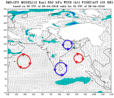
I thought it would be good to show a schematic representation of wind that we discussed so far. See the figure below that is taken from internet.
Generally, the winds are measured at different vertical locations. Three wind locations are important for meteorological studies, namely 10 m above ground (corresponding to 950 millibar (mb) pressure), 1000 m above ground (850 mb pressure) and 4500 m above ground (500 mb pressure). As we move away from the ground, the intensity of wind increases, primarily because of the absence of any obstruction such as buildings, mountains etc. The wind motion on land and ocean has two preferential paths, namely, clockwise and anticlockwise. It is important to note here that the motion of the wind is relative to the earth, which itself is in rotational motion, such that the northern hemisphere (above the equator) feels an anticlockwise motion and the southern hemisphere (below the equator) feels a clockwise motion. In the northern hemisphere, which has an anticlockwise motion, if a wind moves anticlockwise, then the motion of wind is called cyclonic, and if it moves clockwise, then the motion is called anti-cyclonic. This is the basis for genesis of the words ‘cyclones’ and ‘anticyclones’. A cyclonic wind will have the same motion as that of the earth in that particular hemisphere. Therefore, a cyclonic wind will have anti-clockwise motion in northern hemisphere and clockwise motion in the southern hemisphere. Thus, the word cyclonic means that the motion of the earth is going to aid the wind motion. On the other hand, for anticyclonic wind, the motion of earth is going to suppress the wind motion (since the motion of the earth and wind are opposite).
 |
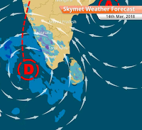
 The cyclonic wind is normally associated with low pressure, and anticyclonic wind is associated with high pressure. Therefore, a low-pressure trough basically refers to a cyclonic wind pattern with moisture in it. The trough does not necessarily have to be local; it could extend from one region to another (as shown by the dotted line in the figure on right). In the figure, the letter ‘C’ marks the cyclonic wind pattern. The dotted line shows the extension of this cyclonic trough.
  | |
 |
| Depression and associated trough |
Therefore, meteorologists are always on the lookout for cyclonic wind motions, their intensity, how big they are (i.e. the span of the cyclonic system), and how much moisture is present in this system. This helps them in making predictions about low-pressure troughs, depression etc. and hence predict the precipitation over land and ocean.
Disclaimer: The content given here are all personal views and the author will not be held responsible or held liable for any oversight or misinterpretation.
Disclaimer: The content given here are all personal views and the author will not be held responsible or held liable for any oversight or misinterpretation.


Clear explanations. Thanks, very helpful.
ReplyDelete