Posts

Southwest Monsoon 2019 withdrawal and North east monsoon Onset

Southwest monsoon 2019 (SWM 2019) saw an active July and still seeing an active August. Thanks to  good rains in both these (crucial) months, overall monsoon rainfall now stands at +1%. This is good news since overall SWM 2019 season seems to be tending towards NORMAL . There are drought hit districts, due to the erratic nature of monsoon, but that discussion is for some other day. SWM 2019 withdrawal to start around September 10, 2019 Normal date for monsoon withdrawal from northern most point of India is September 1st. This date holds true if there are no major western disturbances that form late August or early September.  As I write this blog, North India is expected to receive good rains for the next few days (upto Aug 19) under the influence of monsoon axis, low pressure system, and western disturbance. Looking at the forecast, it seem like weak Western Disturbance is likely to form end of August. If this happens, monsoon withdrawal would be delayed by 1 we...
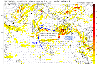
Dynamics behind extreme rains in Ghat section between Aug 06-09, 2019

Image
Very heavy rains are no stranger to Ghat sections of Maharastra, Karnataka, Kerala, and TamilNadu and the districts nestled within the Nilgiris and the Sahyadris. However, extremely extremely heavy rains ( > 300 mm/day) that are continuous in nature require some local dynamics that help in continuous cloud burst like situation. Here, I make an attempt to explain the dynamics behind these events. BAY OF BENGAL SYSTEMS + OFFSHORE TROUGH IN ARABIAN SEA: It all starts from the "Bay of Bengal", where a low pressure system forms. Under the influence of tropical easterlies, these systems move westward towards land, and dissipate due to frictional effects, land cooling effect, and moisture dissipation (i.e. the system runs out of moisture - the heat engine needed to run the system - and hence doesn't sustain).  If the system is strong (i.e. depression or deep depression, it will go all the way to the west coast and sustain for a longer time - e.g. the sys...

Monsoon 2019 for Mumbai - A short coverage

MUMBAI MONSOON 2019 PREDICTIONS: Blog post date: May 28, 2019 Mumbai monsoon is not just a season, it's a celebration. The people of Mumbai eagerly await the first showers, which signals the monsoon onset for the city and brings along nice and pleasant weather, abating the summer heat. The blowing breeze and sound of the dripping water make a delightful experience. The countdown begins... **So, what's in store for the maximum city during Monsoon 2019? Here is my take..** The onset is slightly delayed, owing to a stall in the monsoon currents. But the monsoon should start progressing again starting today/tomorrow. I expect the onset to happen between June 12-15 . This slightly delay in the onset has no bearing on the performance of monsoon during June 2019.  The 15 days are more than enough for Mumbai to reach the climatological June average of ~ 523 mm rainfall. Further, the +IOD conditions would most likely give a push to the monsoon in the later half of Jun...

Revisions to my last post on summer monsoon 2019

************************************** 2019 Monsoon Revised Predictions (Unofficial):       Blog date: May 14, 2019  ************************************** Near timely onset of monsoon   (since ENSO generally does not impact the onset). Hits Kerala on ~ June 2nd.  Mumbai ~ June 12th. 1. Mumbai, Goa, & Kokan - NORMAL 2. Kerala and Peninsular India - NORMAL 3. Central India - NORMAL 4. Coastal Karnataka:  NORMAL 5. East Coast- NORMAL 6. North-East - BELOW NORMAL 7. Gujarat and Northwest - BELOW NORMAL 8. North India- BELOW NORMAL 9. South India (Interior TamilNadu, Interior Karnataka and Andhra) - BELOW NORMAL ****OVERALL SWM 2019 - NORMAL (~ 97% - 98% of LPA) **** **************************** Basis of revision: **************************** In my last post, I had indicated that three factors hold the key, namely, ENSO, IOD, and MJO. In the past month conditions have changed a bit, hence this revision. M...

An early take on our Summer Monsoon 2019

T he buzz is back as the monsoon 2019 season nears. Already a bunch of predictions are pouring over the internet, so here's one more to add to the reader's confusion! :).  *********************** MY PREDICTIONS   (Unofficial): *********************** TIMELY ONSET OF MONSOON (since ENSO generally doesn't impact the onset) -  Hits Kerala on June 1st (+ 2 days).  Mumbai ~ June 11th (+2 days). 1. MUMBAI, GOA, & KOKAN COAST -  NORMAL/SLIGHT EXCESS 2. KERALA  & PENINSULAR INDIA -  SLIGHTLY BELOW NORMAL 3. CENTRAL INDIA, MARATHWADA, VIDARBHA -  BELOW NORMAL 4. EAST COAST -   SLIGHTLY BELOW NORMAL 5. NORTH-EAST -  NORMAL 6. GUJARAT, KUTCH, NORTH WEST -  BELOW NORMAL 7. NORTH INDIA -  NORMAL 8. SOUTH INDIA (INTERIOR TN, INTERIOR KARNATAKA, & AP) -  BELOW NORMAL **** OVERALL SWM 2019 -  BELOW NORMAL (92-95% of LPA) **** OVERARCHING CONCLUSIONS: 1. Interior Karnataka, Andhra, Mar...

North east monsoon 2018 outlook

Most anticipated North East Monsoon (2018) finally made onset of November 1st, after playing hide and seek for the entire month of October. Despite the late onset, some could argue that October for south India was pretty good (especially Kerala and TamilNadu), with some places getting above normal rainfall (especially Nilgiris and Delta regions). Following the onset, the southernmost districts of TamilNadu got lashed, recording first 200 mm daily R/F accumulation. Chennai and rest of TN got moderate rains after the official onset.  After onset, a mini-break was observed, with the UAC system that formed around October 31st getting dissipated. However, another low pressure system (near SriLanka) will keep the NEM active during the Diwali season, with good rains primarily in South TamilNadu and Kerala. Places in North TamilNadu & Chennai, and south Interior Karnataka (e.g. Bangalore, which has not been getting good spells) will have to wait for a...

Tropical cyclones and their dynamics

Image
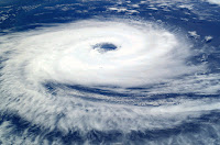
C yclones are massive vortical (i.e. spinning) systems with immense kinetic and thermal energies, which form in the tropical oceans and move inland. They generally have a low pressure central core  surrounded by a high pressure anticyclone that helps in its intensification. Based on the core pressure & sustained peripheral winds, cyclones are categorised on a scale of 1-5. ( see: https://en.wikipedia.org/wiki/Tropical_cyclone_scales ) For any tropical cyclone, six key fluid dynamical parameters govern their genesis & track. (a) Sea surface temperature (>27 deg C for assisting cyclone genesis) (b) Effect of Coriolis force (f - parameter) (c) Low pressure centre (typically < 990 millibars) (d) Wind shear (<10 s  -1 ) (e) Presence of adjacent high pressure envelopes (which hinders with its movement) or any other phenomenon like a Western Disturbance and ITCZ movement. (f) Upper level steering winds. CYCLOGENESIS/INTENSIFICATI...