Posts

Tropical cyclones and their dynamics

Image
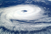
C yclones are massive vortical (i.e. spinning) systems with immense kinetic and thermal energies, which form in the tropical oceans and move inland. They generally have a low pressure central core  surrounded by a high pressure anticyclone that helps in its intensification. Based on the core pressure & sustained peripheral winds, cyclones are categorised on a scale of 1-5. ( see: https://en.wikipedia.org/wiki/Tropical_cyclone_scales ) For any tropical cyclone, six key fluid dynamical parameters govern their genesis & track. (a) Sea surface temperature (>27 deg C for assisting cyclone genesis) (b) Effect of Coriolis force (f - parameter) (c) Low pressure centre (typically < 990 millibars) (d) Wind shear (<10 s  -1 ) (e) Presence of adjacent high pressure envelopes (which hinders with its movement) or any other phenomenon like a Western Disturbance and ITCZ movement. (f) Upper level steering winds. CYCLOGENESIS/INTENSIFICATI...

Why ENSO is local to the Pacific Ocean?

Image
E lNino Southern Oscillation, abbreviated as ENSO, is an interesting and a well-established interseasonal phenomenon that has an immense effect on the tropical monsoons. Very briefly, it is associated with the weakening or full reversal of the atmospheric Walker circulation cell, which forms in the Pacific Ocean. The Walker cell's preferential direction is east-west (easterly), created by the motion of trade winds, supplying moisture to Australia & Indonesia. However, during an ElNino cycle, it either weakens (thereby slowing down the trade winds) or fully reverses, where the trade winds now blow west-east (westerlies).  The Walker cell formation and its modification is driven by the ocean dynamics. During non-ElNino or neutral years, a cold pool exists in east Pacific - near South American coast due to upwelling (specifically Chile coast), and a warm pool is formed in the west Pacific - near Australia. This set up is quashed by a Kelvin wave , which one can  ...

A look back at SWM 2018 and outlook for NEM 2018

W ith almost 75% of the Southwest Monsoon (SWM) season gone by, we enter the last leg of SWM 2018. A lot to cherish about SWM 2018 but at the same time, the erratic pattern of SWM 2018 won't be forgotten (#Kerala floods, #Kodagu floods, #Bihar drought etc.). The SWM 2018 made an early and powerful onset, but lost steam around end of July and August, bringing widespread fear about below normal monsoon. Current we are staring at a deficit of ~8%.  Had it not been for the very heavy rains in Kerala, the deficit would have been in double digits.  August is going to end on a larger deficit, compared to June and July. Inspite of three back to back low pressure systems in the #BayofBengal, August underlined the “Vagaries of Monsoon” -  be it in terms of below average countrywide rains or circulation system positioning itself at one place for a week and delivering non-stop rains). Overall, SWM 2018 couldn't keep up the pace with which it started. This is not surprising ...

A blog for weather enthusiasts: Parameters to analyse before giving advisories on Indian weather

Image
Recently, there has been an increase in the number of weather enthusiasts who are putting out  blogs and tweets for social cause, primarily with an intention of helping the locals as well as the farming community. India has a rich equatorial dynamics, which is extremely hard to comprehend and hence weather enthusiasts (in groups and individual) are making an effort to disseminate weather related advisories to the society.  I myself found that my passion lies in weather analysis (which is also a part of my academic research), and I should put my knowledge to use in an effective manner. With this intention, I started blogging and tweeting posts about weather conditions (both on national and regional scale). The main motive of this blog is to share my experience, as to how I go about reading the models and charts before giving out advisories. There are five parameters that I look at, which I call “Five Point Analysis (FiPA)” . They are as follows: (a) 850 mb Geopote...

Bountiful start to monsoon 2018 for Kerala & Karnataka

Image
The early onset of 2018 monsoon season was in itself a welcome news for south peninsular India, which has been experiencing below average monsoon for quite sometime now (2015, 2016 & 2017). The icing on the cake has been the torrential downpour from the start of the monsoon season up until now, where almost all the stations in Kerala, South coastal Karnataka, Nilgiris and adjoining areas have recorded excess rainfall, with some stations recording large excess ( on the right season's rainfall for Kerala is shown, source IMD ). While overall this is a great beginning, with record rainfall activity in these places, there is always a downside to such bountiful monsoon showers, that being - floods, loss of lives, overflowing reservoirs, and damage to infrastructure. To a large extent, we could blame these punitive damages to lack of proper government planning during monsoon period, where proper care should be taken for tropical countries, which shoulder the wrath of monsoons, b...

A tale of storms - thunder & dust

Image
Over the past couple of weeks, stormy weather has gripped India, especially north India and to some extent south and north-east India (although not covered in the news as much as the thunder-and dust-storms in north India). The central and western regions have been undergoing somewhat of a lull period with no significant activity. Press coverage on recent storms can be accessed at - 1.  https://www.washingtonpost.com/news/worldviews/wp/2018/05/08/dust-storms-create-havoc-across-india/?noredirect=on&utm_term=.47578e1a2a9e 2.  https://scroll.in/article/878105/as-north-india-braces-for-thunderstorms-vague-weather-alerts-are-of-little-help 3.  https://www.independent.co.uk/news/world/asia/india-dust-storms-thunder-death-toll-weather-delhi-agra-rajasthan-uttar-pradesh-latest-a8335891.html Although thunderstorms are a common feature during the summer time, the freak event that occurred on May 2nd is very uncommon and could be attributed to the changing cli...

Onset of Indian summer monsoon

Image
The onset of Indian summer monsoon (or southwest monsoon) is the most anticipated event for the Indian population. The first monsoon shower is the most awaited one as many seek respite from the scorching heat, little ones gleefully wanting to play in the cool showers, and the agricultural community get in full swing to prepare the land for farming. Over the past few years, owing to climate change, the onset has been delayed ( https://www.firstpost.com/economy/imd-forecasts-delay-in-onset-of-monsoon-may-hit-kerala-coast-around-5-june-1971211.html ) and the monsoon itself has been erratic, with brief periods of heavy rain (active phase) and periods of no rain (break phase). This is in contrast to a decade or two back, when the onset on monsoon would be well-timed and the nature of monsoon was also steady (with consistent rains through out the season). However, urbanisation, greenhouse pollution, deforestation, and many other anthropogenic activities have led to the late onset and incon...